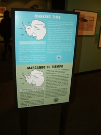
 National Science Foundation (NSF) Antarctic Artist and Writers Program awardee Xavier Cortada marks the passage of time by exploring important world events that have moved the world forward during the past 50 years.
The South Pole
 On December 14, 1911, Norwegian Roald Amundsen was first to reach the South Pole. The geographic South Pole is located near the center of the Antarctic ice sheet at an altitude of 2800 meters. The ice sheet covering the Pole is moving at about 10 m per year toward the Weddell Sea (along the 60 degree West meridian). Each year, staff at the South Pole station reposition the South Pole marker to compensate for the movement of the ice.
On October 31, 1956, Lt. Shinn landed the first plane, “Que Sera Sera,” at the South Pole. Three weeks later, on November 20, 1956, the first South Pole station construction crew arrived.
On January 4, 1957, the Navt Seabees crew turned the completed station over to a team of nine scientists, nine support professionals (e.g.: a doctor, a cook) and a dog who wintered over and officially opened the base to scientific exploration.
The Installation
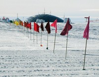
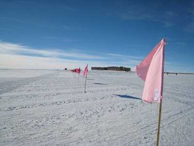 On January 4, 2007, on the 50th anniversary of the opening of the South Pole station, Miami artist Xavier Cortada arrived at the South Pole and planted 51 differently-colored flags along a 500-meter stretch of a moving ice sheet. The last flag was planted where South Pole stood in 1956, when the Pole became permanently inhabited. The first, where the South Pole stands fifty years later.
Each flag is marked with its respective year, and with the coordinates of a place on Earth the artist selected as important in “moving the world forward” during that year (e.g.: 1957 is Sputnik, 1963 is the March on Washington, 1969 is the Lunar Landing, 1997 is the Kyoto Accord) while scientists worked in the South Pole.
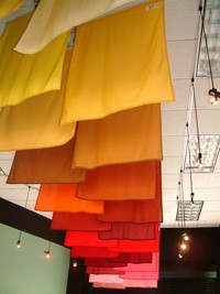
The Marker flags were exhibited at the Miami Museum of Science and Planetarium prior to being installed in the South Pole.
Cortada’s Markers
Xavier Cortada selected the following events to mark how the world has moved forward in the past fifty years:
| 1956 | 90°S | 90°S | Antarctica | Construction crews arrive at the South Pole | |
| 1957 | 47°50’N 66°03’E | 47°50’N 66°03’E | Soviet Union | Sputnik, the first satellite to orbit Earth, is launched into space from Baikonur, USSR | |
| 1958 | 48°52’N 02°20’E | 48°52’N 02°20’E | France | Pan Am’s transatlantic 707 flight lands in Paris, jet age begins | |
| 1959 | 32°47’N 96°48’W | 32°47’N 96°48’W | United States | Microchip is invented | |
| 1960 | 11°21’N 142°12’E | 11°21’N 142°12’E | Pacific Ocean | Trieste dives to the bottom of the Mariana Trench: 35,813 feet | |
| 1961 | 47°50’N 66°03’E | 47°50’N 66°03’E | Soviet Union | Yuri Gagarin is first man in space (launched from Baikonur) | |
| 1962 | 42°22’N 71°04’W | 42°22’N 71°04’W | United States | Rachel Carson’s Silent Springis published | |
| 1963 | 38°53’N 77°02’W | 38°53’N 77°02’W | United States | March on Washington for Civil Rights | |
| 1964 | 40°43’N 74°00’W | 40°43’N 74°00’W | United States | Beatlemania sweeps America | |
| 1965 | 23°08’N 82°22’W | 23°08’N 82°22’W | Cuba | Freedom Flights for Cuban refugees begin | |
| 1966 | 28°40’N 77°13’E | 28°40’N 77°13’E | India | Indira Gandhi elected first woman prime minister of India, the world’s largest democracy | |
| 1967 | 33°55’S 18°22’E | 33°55’S 18°22’E | South Africa | First human heart transplant | |
| 1968 | 55°45’N 37°35’E | 55°45’N 37°35’E | Soviet Union | Nuclear Non-Proliferation Treaty signed in Moscow, London and Washington, D.C. | |
| 1969 | 28°24’N 80°36’W | 28°24’N 80°36’W | United States | The Eagle lands on the moon (launched from Cape Canaveral) | |
| 1970 | 13°06’N 59°37’W | 13°06’N 59°37’W | Barbados | Ra II crosses Atlantic in 57 days | |
| 1971 | 37°21’N 121°16’W | 37°21’N 121°16’W | United States | Microprocessor is invented | |
| 1972 | 39°55’N 116°25’E | 39°55’N 116°25’E | China | Nixon visits China | |
| 1973 | 33°86’S 151°22’E | 33°86’S 151°22’E | Australia | Sydney Opera House is built | |
| 1974 | 08°59’N 40°10’E | 08°59’N 40°10’E | Ethiopia | Skeleton of “Lucy,” our 3.2 million year old ancestor, is discovered | |
| 1975 | 19°24’N 99°09’W | 19°24’N 99°09’W | Mexico | United Nations convenes First World Conference on Women | |
| 1976 | 28°24’N 80°36’W | 28°24’N 80°36’W | United States | Viking I and II land on Mars (launched from Cape Canaveral) | |
| 1977 | 01°43’N 44°53’E | 01°43’N 44°53’E | Somalia | Smallpox eradicated from Earth | |
| 1978 | 53°33N 02°07’W | 53°33N 02°07’W | England | First test tube baby born | |
| 1979 | 40°01’N 105°16’W | 40°01’N 105°16’W | United States | Ten independent living centers were founded across the US for persons with disabilities | |
| 1980 | 54°23’N 18°40’E | 54°23’N 18°40’E | Poland | Solidarity strikes across Poland | |
| 1981 | 41°08N 73°42’W | 41°08N 73°42’W | United States | IBM launches personal computer | |
| 1982 | 50°50’N 0°08’W | 50°50’N 0°08’W | England | Whale hunting moratorium enacted | |
| 1983 | 41°54’N 12°27’E | 41°54’N 12°27’E | Vatican City | Pope John Paul II retracts the ban on Galileo | |
| 1984 | 37°19’N 122°02’W | 37°19’N 122°02’W | United States | Apple Macintosh launched | |
| 1985 | 09°02’N 38°42’E | 09°02’N 38°42’E | Ethiopia | Live Aid concerts raise millions to reduce famine | |
| 1986 | 14°37’N 121°00’E | 14°37’N 121°00’E | Philippines | Corazon Aquino leads People Power to end Marcos regime in the Philippines | |
| 1987 | 39°46’N 86°09’W | 39°46’N 86°09’W | United States | Anti-depressant Prozac is introduced | |
| 1988 | 33°27’S 70°40’W | 33°27’S 70°40’W | Chile | Chile plebiscite ends dictatorship, ushers in democracy across South America | |
| 1989 | 52°30’N 13°25’E | 52°30’N 13°25’E | Germany | Berlin Wall is knocked down | |
| 1990 | 51°04’N 01°51’E | 51°04’N 01°51’E | English Channel | Tunnel links UK and Europe | |
| 1991 | 55°45’N 37°35’E | 55°45’N 37°35’E | Russia | Russia becomes “independent” as the Soviet Union collapses | |
| 1992 | 22°53’S 43°06’W | 22°53’S 43°06’W | Brazil | First Earth Summit’s Rio Declaration has 153 countries focus on sustainable development | |
| 1993 | 40°11’N 88°26’W | 40°11’N 88°26’W | United States | World Wide Web browser is created, distributed | |
| 1994 | 25°45’S 28°10’E | 25°45’S 28°10’E | South Africa | Apartheid ends in South Africa, Mandela elected president | |
| 1995 | 44°40’N 111°06’W | 44°40’N 111°06’W | United States | Grey wolves return to the American West | |
| 1996 | 76°43’S 159°40’E | 76°43’S 159°40’E | Antarctica | NASA announces that the Antarctic’s ALH 84001meteorite points to existence of life on Mars | |
| 1997 | 35°00’N 135°45’E | 35°00’N 135°45’E | Japan | Kyoto Protocol enacted | |
| 1998 | 03°10’N 101°42’E | 03°10’N 101°42’E | Malaysia | Petronas Towers topped at 1483 ft., the tallest building at that time | |
| 1999 | 09°32’N 21°72’E | 09°32’N 21°72’E | Egypt | Breitling Orbiter 3 hot air balloon sails non-stop around the world | |
| 2000 | 33°52’S 151°13’E | 33°52’S 151°13’E | Australia | Cathy Freeman, the Aboriginal runner, wins Olympic gold | |
| 2001 | 12°03’S 77°03’W | 12°03’S 77°03’W | Peru | A 4,000-year-old site yielded the remains of the oldest known city in the New World | |
| 2002 | 15°46’S 47°55′W | 15°46’S 47°55’E | Brazil | Brazil Soccer wins 5th World Cup | |
| 2003 | 52°13N 00°08’W | 52°13N 00°08’W | England | Human Genome Project completed | |
| 2004 | 37°23’N 122°05’W | 37°23’N 122°05’W | United States | Google, digital music, wireless technologies and blogs boomed | |
| 2005 | 20°24’N 03°41’W | 20°24’N 03°41’W | Spain | Spain ends all discrimination based on sexual orientation | |
| 2006 | TBA | 0°0’N 0°0’W | Easter Island | Scientists discover new species | |
| 2007: |
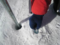
At the location of the 2007 Geographic South Pole marker, the artist planted a mangrove seedling from Miami’s Biscayne Bay, 25°46’N 80°12’W. (Cortada’s “150,000-year Journey” project also addresses the passage of time, asking us to see time in geologic instead of human time frames. To learn more about the 150,000-year Journey, please visit http://cortada.com/art2007/art-in-antarctica/150000-year-journey/.) | ||||
About the Installation
 Xavier Cortada’s installation highlights events that have moved our world forward in the time it has taken the Antarctic ice sheet to move about 500 meters. Cortada chronicles the passage of time by depicting those events on flags he placed at the South Pole on January 4, 2007. To accomplish this, the artist:
1. Created 51 differently colored flags, ranging from violet to red, each sequentially representing years from 1956 to 2006.
2. Marked each flag with the coordinates of a place where an event took place that moved the world forward during that given year (e.g., 1963’s March on Washington, 1989’s Fall of the Berlin Wall).
 3. Planted each year’s flag in the location on the ice where all the meridians converged during that flag’s respective year; that is, where the South Pole stood during that given year. (Since the South Pole, 90°S, sits on a glacier that is in constant motion, its location on the ice above changes every year).
When the flags were planted they created a spectrum of color on the white surface of the ice. The first flag was planted at the location of the 2006 Geographic South Pole, with each subsequent flag spaced 9.9 meters apart and aligned in the direction of the Weddell Sea. Since the glacier below is moving everything in the same direction at 9.9 meters annually, the flags “mark” where the South Pole stood in any given year– few places on Earth can so dramatically mark the passage of time.
Left: The Markers’ flags on display at the Miami Museum of Science before being installed by the artist in the South Pole.